A globe-spanning advanced civilization called Tartaria was erased from history and its architecture stolen and reattributed
By Colin PetersonJuly 12, 2026
Where the evidence lands: Contradicted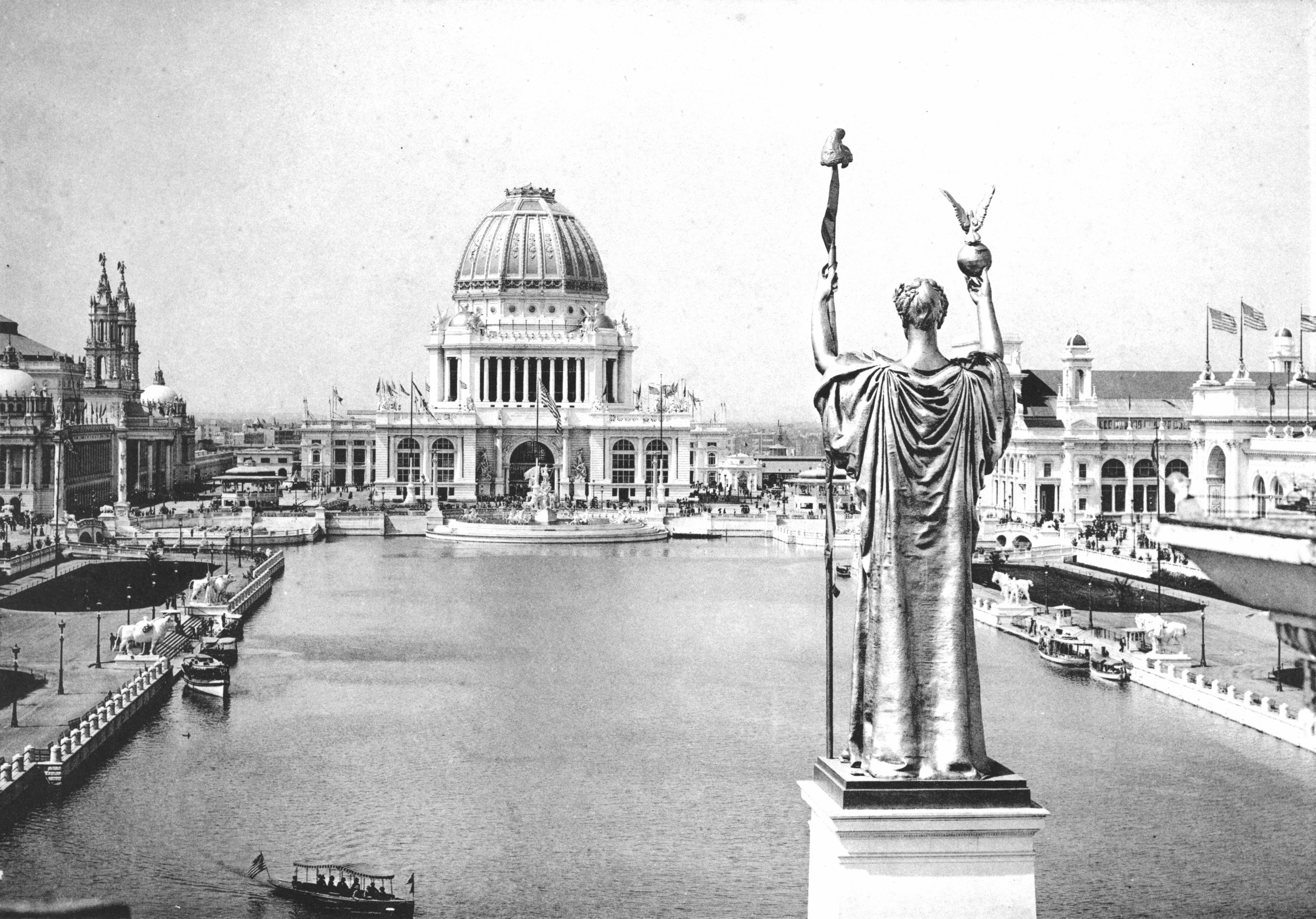
That a single, technologically advanced civilization called Tartaria once spanned much or all of the globe; that its achievements included free or wireless energy and monumental architecture; that mainstream historians, governments, and institutions deliberately erased it from the record and reattributed its buildings (world's-fair pavilions, ornate government buildings, star-shaped forts, grand railway stations) to later, lesser builders; and that a worldwide cataclysm, the mud flood, buried its lower floors, which is why so many old buildings have windows and doors below today's ground level.
Contradicted. There is a real kernel: Tartary was a genuine early-modern European map label for the vast, poorly-known interior of Central and North Asia, and it really did fade from atlases as European geography improved. The modern conspiracy inflates that vague cartographic word into a suppressed, technologically advanced worldwide empire whose grand buildings were supposedly stolen and reattributed, with a global mud flood burying the evidence. Every plank of that story has a documented, ordinary explanation. Architectural styles, temporary world's-fair pavilions, raised street levels, and old maps are misread and cherry-picked. No serious historian, geographer, or archaeologist accepts it, and the theory is debunked.
Believed by: An online subculture of history skeptics, architecture-nostalgia accounts, and alternative-history YouTubers, spread through short video, before-and-after photo comparisons, and reposted antique maps
The full story
A real word on old maps
Open a European atlas from the seventeenth or eighteenth century and, sprawling across the interior of Asia, you will often find a single word: Tartary, or in Latin, Tartaria. It covers an enormous space, from the Caspian Sea and the Ural Mountains eastward toward the Pacific, sometimes broken into Great Tartary, Chinese Tartary, Little Tartary, and Independent Tartary. It is on maps by Ortelius, by Blaeu, by respectable cartographers whose work sits in the world's great collections. This part is entirely real, and it is where the theory begins.
What the word actually meant is the first thing the theory gets wrong. Tartary was an exonym: a name Europeans applied from the outside to a region they barely knew. It derived from Tatar, a label pinned loosely and often inaccurately onto many different Central and North Asian peoples. Mapmakers reached for “Tartary” the way earlier maps reached for vague labels over blank interiors, as a placeholder for territory that had not yet been surveyed in detail. It never named a single government, a shared culture, or a unified empire.
And then it faded, for the most ordinary reason imaginable. As European surveying, ethnography, and imperial mapmaking grew more precise in the nineteenth century, the vague label was replaced by specific regions and nations: Siberia, Mongolia, Manchuria, the Central Asian khanates. By the late 1800s, Tartary had quietly dropped out of atlases and textbooks. A discarded word, not a deleted world. From that unremarkable fact, the modern theory builds an empire.
The case as believers make it
Set out honestly, the pitch has a genuine pull, and it is worth stating at its strongest before answering it. Here, believers say, is a word that once covered a third of a continent and then simply vanished from the maps. Why were you never taught about it? Around that question they assemble a gallery of images that really are striking.
Look, they say, at the architecture. The demolished original Penn Station, the lost Singer Building, the sprawling ornate palaces of the 1893 Chicago and 1915 San Francisco world's fairs: structures of a grandeur and craft that dwarf the glass boxes we build now. Could a young, still-developing country really have thrown up such things in a matter of months, only to tear them down again? Or were they, as the theory proposes, inherited from an older and greater civilization and then quietly reattributed to lesser builders?
Then come the buildings whose windows and doorways sit below the modern street, half-buried, as if something had risen up around them. And the star forts, those elegant, geometric, angular fortifications that appear all over the world with an almost suspicious uniformity of design. Believers stitch these together into a lost golden age of monumental building and even free, wireless energy, wiped out by a cataclysm and then covered up. Told with sepia photographs and antique maps, in a short video with the right music, it can feel less like an argument than a revelation.
The images are real and often beautiful. The empire assembled from them is not, and every plank has an ordinary, documented explanation.
What the record actually shows
The theory collapses because each of its pillars has a documented, mundane explanation, and the documentation is abundant rather than scarce.
The architecture is not mysterious.The grand old buildings belong to well-understood styles, chiefly Beaux-Arts and neoclassical, with a fully traceable history. These were deliberate revivals of Greek, Roman, and Renaissance forms, taught at institutions like the École des Beaux-Arts in Paris and carried around the world by named architects whose drawings, budgets, and correspondence survive. The world's-fair palaces looked monumental because they were theatrical set pieces, built fast and cheap from plaster, wood, and staff, a plaster-and-fiber mixture molded to imitate carved stone. They were meant to be temporary, which is exactly why they were demolished within a year or two of the fair closing. Construction photographs, contractor records, and newspaper reports document these projects in detail.
The mud flood is raised streets, not a cataclysm.Buildings with windows and doors below today's pavement usually sit in cities that deliberately raised their street levels for drainage and sanitation. After its 1889 fire, Seattle regraded downtown roughly a full story higher, leaving the old sidewalks entombed as the tourist-friendly Seattle Underground. Chicago, in the 1850s and 1860s, literally jacked entire buildings and streets upward to fit a new sewer system beneath them. Add ordinary features like basement windows, light wells, and semi-sunken entries, plus the natural way ground level rises over decades through construction and fill, and the “buried” look is fully explained. A genuine global mud flood would have left a worldwide sediment layer; none exists.
Star forts are military engineering. Their shape is the trace italienne, developed in Renaissance Italy to answer gunpowder artillery. Low, thick, angled ramparts deflected cannonballs, and the projecting bastions let defenders rake every wall with crossfire, a solution tall medieval walls could not provide. The design spread through printed treatises and traveling military engineers, which is precisely why it looks so uniform across countries. There is no wiring, no mechanism, and no physics by which such a fort gathers energy, and none has ever been shown.
The cover-up is the weakest link of all. Erasing a globe-spanning civilization would mean silently rewriting the archives, censuses, newspapers, building records, and photographs of every nation on Earth, across mutually hostile governments with no reason to collaborate, while conveniently leaving intact the very maps and buildings the theory points to. The simpler account explains everything with no conspiracy: the buildings are what their paperwork says, and the map word was retired as geography improved.
Why it took hold
A theory this thoroughly answerable still found a real audience, and the reasons say more about the present than about any lost past. The first is that it opens with a true fact. There was a Tartary on old maps, and it did disappear from newer ones. That true opening earns just enough trust to carry the invented empire in behind it.
The second is aesthetic, and it is worth taking seriously rather than mocking. The old Penn Station really was more beautiful than what replaced it; ornate railway stations and demolished landmarks really do outshine much of what we build now. Tartaria channels a genuine grief at that loss into a flattering story: such beauty could not belong to ordinary developers and forgotten architects, so it must be the relic of a hidden golden age. The nostalgia is real even though the empire is not.
The third is the deep satisfaction of they lied to you. Reframing mainstream history as a coordinated cover-up turns a gap in one's own education into suppressed secret knowledge, and turns the believer into an awakened investigator rather than someone who simply had not looked it up. That is a far more thrilling self-image than the truth on offer, which is that the buildings are documented and the map word was retired.
The medium did the rest. The theory's evidence is visual and endlessly shareable: a sepia photograph, a cropped before-and-after, an antique map with a dramatic caption. None of that does the archival work that would actually test the claim, but it does not need to in order to spread. It only needs to feel like proof for the few seconds a video holds your attention.
Architecture, not a lost empire
The rating is debunked, and unusually cleanly so. Unlike cases where a documented core sits beside an overstated tier, here the only real element is small and cartographic: Tartary was a genuine, vague European label for a poorly-known part of Asia, and it genuinely faded from the maps. Everything built on top of that, the advanced worldwide empire, the stolen and reattributed architecture, the mud flood, the free-energy star forts, the global cover-up, is invented, and each piece is contradicted by ordinary, abundant evidence.
The honest way to hold it is to grant the believers their images and then explain them. The old maps are real, and they meant something far more modest than an empire. The grand buildings are real, and they were designed, built, documented, and in the case of the fair pavilions deliberately demolished by known people in known styles. The buried doorways are real, and cities raised their own streets to make them. The star forts are real, and they were built to survive cannon fire. Nothing in the set requires a lost civilization, and the record we do have could not survive the erasure the theory needs. The beauty that draws people to Tartaria is worth mourning; the empire is not worth believing.
What's still unexplained
- None of the theory's core claims are genuinely open. The map label, the architecture, the raised streets, and the star forts each have settled, documented explanations, and no anomaly requires a lost global civilization to resolve it.
- The honest open questions are historical and psychological rather than evidentiary: exactly how the Russian-language pseudohistory of the 2000s mutated into the global English-language version after 2016, and why architecture nostalgia proved such fertile ground for it, are worth studying as a case history of how a real toponym gets inflated into a myth.
Point by point
The claim: Old maps clearly label a huge empire called Tartaria, so it must have existed and been erased.
What the record shows: The maps are real; the reading is wrong. Tartary was an exonym, a European catch-all for a vast region its mapmakers barely knew, not the self-name of a unified state. It functioned like other now-retired labels for poorly-understood areas. It never denoted a single government, let alone a technologically advanced world empire. The word faded from atlases in the nineteenth century for the same reason many vague old labels did: better surveying and ethnography replaced it with specific, named regions. A discarded geographic term is not a deleted civilization.
The claim: Grand nineteenth-century buildings and world's-fair pavilions were too advanced and too beautiful for their era, so they must be inherited Tartarian architecture, later reattributed.
What the record shows: Their design, construction, architects, budgets, and demolitions are exhaustively documented. Beaux-Arts and neoclassical styles have a traceable history, taught at schools like the École des Beaux-Arts and deliberately reviving Greek, Roman, and Renaissance forms. World's-fair buildings looked monumental precisely because they were stagecraft: pavilions like those of the 1893 Chicago and 1915 San Francisco expositions were built from plaster, wood, and staff (a plaster-and-fiber mix imitating stone) and were designed to be temporary, which is why they were torn down within a year or two. Blueprints, photographs of the construction, contractor records, and newspaper accounts survive for these projects.
The claim: Many old buildings have windows and doorways below today's ground level, proving a mud flood buried their lower floors.
What the record shows: Below-grade windows and raised street levels have prosaic, well-recorded causes. Cities deliberately raised their streets for drainage, sewers, and flood control: after the 1889 fire, Seattle regraded downtown roughly a story higher, generally about twelve feet and in places far more, leaving the old sidewalks as the Seattle Underground. Chicago physically jacked up buildings and streets in the 1850s and 1860s to install a sewer system. Basement windows, semi-below-grade entries, and light wells are ordinary architectural features, and ground level naturally rises over time through construction and fill. None of it requires a global mud cataclysm, and no worldwide sediment layer of the kind such an event would leave has ever been found.
The claim: Star-shaped forts around the world share a design too sophisticated and uniform to be coincidence, so they are Tartarian energy devices.
What the record shows: Star forts are one of the best-documented developments in military engineering. The angled-bastion design, the trace italienne, emerged in Renaissance Italy as a direct response to gunpowder artillery: low, thick, angled ramparts deflected cannon fire and let defenders sweep every approach with crossfire, unlike tall medieval walls. The design spread across Europe and its colonies through published treatises and traveling engineers, which is exactly why it looks uniform. Their purpose was defensive, not energetic; there is no mechanism, wiring, or physics by which a masonry fort collects free energy, and no such energy has ever been demonstrated.
The claim: Historians and governments coordinated to erase Tartaria from the record, which is why you were never taught about it.
What the record shows: A cover-up on this scale is not just unproven, it is impossible to reconcile with the surviving record. Erasing a global civilization would require silently rewriting the archives, libraries, building records, censuses, newspapers, and photographs of every country on Earth, across rival governments with no reason to cooperate, while leaving the very maps and buildings the theory cites fully intact. The far simpler explanation, that the buildings are exactly what their abundant documentation says and the map label was retired as geography improved, accounts for all the evidence without any conspiracy at all.
Timeline
- 13th–19th centuriesEuropean cartographers use Tartary (Latin Tartaria) as a blanket label for the large, poorly-mapped interior of Central and North Asia, from the Caspian and the Urals toward the Pacific. Subdivisions like Great Tartary (Siberia), Chinese Tartary (Manchuria), Little Tartary (the Crimea), and Independent Tartary (western Central Asia) appear on maps by Ortelius, Blaeu, and others. The word derives from Tatar, an exonym applied loosely to many different peoples.
- 19th centuryAs European ethnography, surveying, and imperial cartography grow more detailed, the vague Tartary label falls out of use. It is steadily replaced on maps by specific regions and nations, and by the later nineteenth century it has largely vanished from atlases and textbooks. This ordinary retirement of an outdated toponym is the fact the theory later reframes as a deliberate erasure.
- 2000s–early 2010sIn Russian-language internet circles, fringe pseudohistory reinterprets the old Tartary maps as proof of a suppressed Slavic or Eurasian super-empire. This early strain, tangled up with nationalist mythmaking, supplies the raw material (antique maps plus a suppression narrative) for the later global version.
- c. 2016An English-language movement coalesces on YouTube, Reddit, and image boards. Creators post side-by-side comparisons of ornate old buildings, antique maps, and sepia photographs, arguing that a lost worldwide civilization built structures too grand for their supposed era. The mud-flood motif, that a cataclysm buried the ground floors of old buildings, becomes a central organizing idea.
- 2020–2021The theory peaks during the pandemic's surge in online time. It fuses architecture nostalgia with familiar conspiracy furniture: suppressed free energy (often invoking Nikola Tesla and star forts as antennas), reset cataclysms, and mass institutional lying. Mainstream coverage follows, including a widely-read 2021 Bloomberg CityLab feature examining the movement.
- 2021 onwardHistorians, geographers, and architecture writers publish debunkings. The Russian Geographical Society, holder of many genuine Tartary maps, dismisses the empire claim as fantasy while sharing the real cartographic history. The theory persists as an aesthetic-driven subculture rather than gaining any scholarly foothold.
Contradicted. There is a real kernel: Tartary was a genuine early-modern European map label for the vast, poorly-known interior of Central and North Asia, and it really did fade from atlases as European geography improved. The modern conspiracy inflates that vague cartographic word into a suppressed, technologically advanced worldwide empire whose grand buildings were supposedly stolen and reattributed, with a global mud flood burying the evidence. Every plank of that story has a documented, ordinary explanation. Architectural styles, temporary world's-fair pavilions, raised street levels, and old maps are misread and cherry-picked. No serious historian, geographer, or archaeologist accepts it, and the theory is debunked.
Reviewed by Colin Peterson · Last reviewed July 12, 2026 · How we rate
Common questions
Is Tartaria true?
Contradicted. There is a real kernel: Tartary was a genuine early-modern European map label for the vast, poorly-known interior of Central and North Asia, and it really did fade from atlases as European geography improved. The modern conspiracy inflates that vague cartographic word into a suppressed, technologically advanced worldwide empire whose grand buildings were supposedly stolen and reattributed, with a global mud flood burying the evidence. Every plank of that story has a documented, ordinary explanation. Architectural styles, temporary world's-fair pavilions, raised street levels, and old maps are misread and cherry-picked. No serious historian, geographer, or archaeologist accepts it, and the theory is debunked.
What is Tartaria?
On old European maps, a huge stretch of Asia is labeled Tartary, or in Latin Tartaria. It was a real toponym, a vague catch-all for lands Europeans knew little about, and it quietly disappeared as their maps got better. A modern internet movement takes that faded label and builds an empire on it: a lost, technologically advanced, globe-s…
What does the evidence show?
The maps are real; the reading is wrong. Tartary was an exonym, a European catch-all for a vast region its mapmakers barely knew, not the self-name of a unified state. It functioned like other now-retired labels for poorly-understood areas. It never denoted a single government, let alone a technologically advanced world empire. The word…
Why do people believe it?
It starts from something real. There genuinely was a place labeled Tartary on old maps, and it genuinely disappeared from later ones, so the opening move (here is a real thing you were not taught much about) lands before the invented empire is smuggled in.
What is still unresolved?
None of the theory's core claims are genuinely open. The map label, the architecture, the raised streets, and the star forts each have settled, documented explanations, and no anomaly requires a lost global civilization to resolve it.
Sources
- 1.Tartary, Wikipedia
- 2.Tartarian Empire (pseudohistory), Wikipedia
- 3.Tartarian Empire: Inside Architecture's Wildest Conspiracy Theory, Bloomberg CityLab (Zach Mortice) (2021)
- 4.Tracking “Tartary” on Western Maps, Library of Congress (Worlds Revealed blog) (2025)
- 5.What Is the Lost Empire of Tartaria, and the Mud Flood Conspiracy?, Discover Magazine (2024)
- 6.Seattle Underground, Wikipedia
- 7.Star Forts Are Military History, and the Base of Some Strange Conspiracy Theories, Atlas Obscura (2021)
- 8.Panama-Pacific International Exposition, Wikipedia
Embed this verdict on your site
Paste this snippet to show our sourced verdict as a small card, with a link back to the full case file. Free to use.
<iframe src="https://theconspiratory.com/embed/tartaria-mud-flood" title="The Conspiratory verdict" width="520" height="190" style="border:0;max-width:100%" loading="lazy"></iframe>Help us investigate
This is a living case file. If you spot an error or know evidence we missed, tell us, and weigh in on where you land.
Where do you land?
Cast your read on this one.
Comments
Add your take. Comments are read and approved by a human before they appear, so keep it on topic and civil. Please do not accuse named, living people of crimes.